
Our Guide to 15 Great Hikes in Scottsdale, Arizona

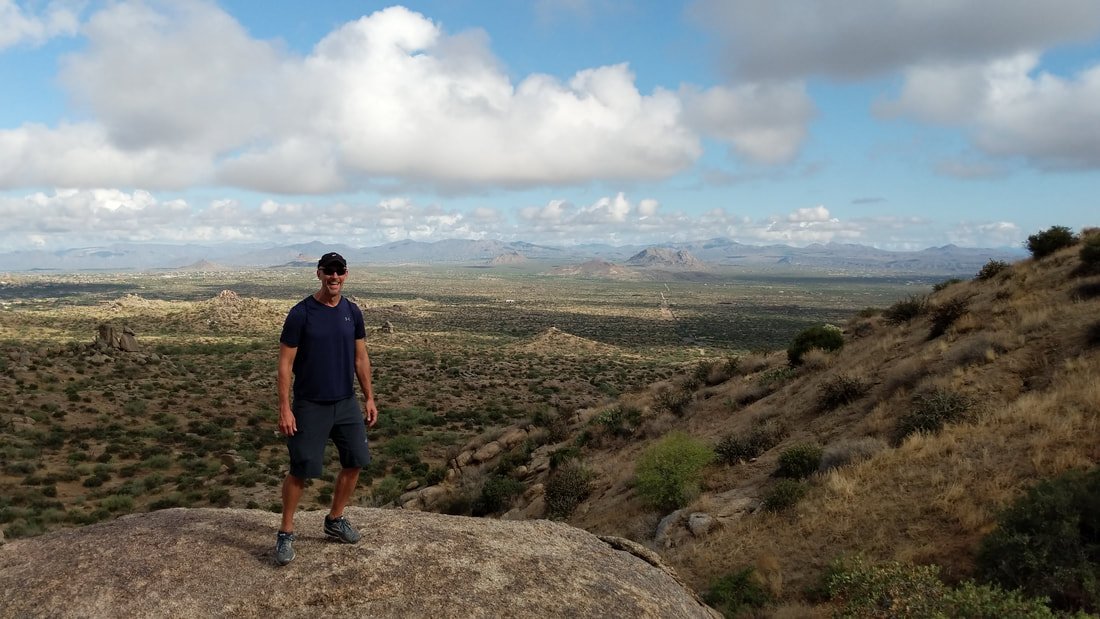
The stunning summit views on Tom's Thumb Trail, just one of the fun hikes we discovered on a recent trip to Scottsdale.
Colleen and I went on vacation to Scottsdale, Arizona, as we have done frequently over the past decade-plus. Our first trip to this delightful destination in the Sonoran Desert was in 2005 for our honeymoon.
We find the autumn weather in the Valley of the Sun to be just what we need to extend our summer. July and August are notoriously scorching in Phoenix and Scottsdale, reaching triple digits daily. But when fall arrives, the furnace starts to cool a bit, and we find the temps just right, low 80s to low 90s for much of the time from mid-September and into October.
This time of year, it’s just wonderful to be outside and enjoying the sunshine during the day and warm desert nights with clear starry skies. So, that’s when we go, checking in for a week at our favorite resort Westin Kierland Villas, which puts us close to Old Town Scottsdale, Kierland Commons and plenty of restaurant and entertainment options.
But we really love it because we're in the heart of a recreational wonderland, an especially good place for hiking and running. We got out for three hikes during our most recent visit to Scottsdale, and we discovered numerous others that we'll work through on our return trips.
Here is our guide to 15 great hikes in and around Scottsdale.
1. Tom's Thumb Trail
Length: Five miles out and back.
Difficulty: Moderate to difficult
What to know: This beautiful hike in the McDowell Sonoran Preserve in North Scottsdale offers the chance to explore some of the most stunning rock formations in the region. We chose the Tom's Thumb trail up to the distinctive formation at the very peak, but this preserve features a number of hikes that give views of the expansive McDowell Mountain Range. A large parking lot is on site, and the hike requires no fee. The views along the hike are indeed incredible, and you can take several photo breaks at designated viewing points. This is a steep switchback trail that is rocky at points but is extremely well maintained and popular for visitors and residents.
2. Pinnacle Peak Park
Length: A 3.5-mile out-and-back trail that rises and falls in elevation as you go.
Difficulty: Moderate
What to know: You have spectacular views of the valley from all around as you progress along the route. The hike starts at an information center, and the first portion of the trail is filled with signs that describe the flora, fauna and geology of the park. The hike also has well-marked access to rock climbing areas. There is a large parking lot, and trail access is free. The cumulative elevation gain is 1,300 feet, with the highest point on the route at 2,889 feet and the lowest 2,366.
Camelback Mountain Hikes
Camelback is one of the most popular outdoor destinations in Arizona, a mecca for hikers and rock climbers. The range, of course, offers a number of great hiking trails.
3. Echo Canyon Trail
Length: This is a 2.6-mile out-and-back hike.
Difficulty: Strenuous
What to know: Get there early. Gates open at sunrise, and parking is limited and parking regulations are strictly enforced. There is no fee for this hike, which is rocky, steep and with little shade. The route features beautiful wildflowers and views (try to spot Four Peaks once you reach the top). At the top, you can see out over Phoenix and Scottsdale.
4. Cholla Trail
Length: A 3-mile out-and-back route.
Difficulty: Strenuous
What to know: This trail is best used from May through September and also is a nice option for viewing wildflowers and other desert plants. This popular trail is well marked, gets hot (bring extra water) and can be crowded even if you head out at sunrise. The steep route gains about 1,250 feet in elevation over 1.5 miles to the top, where you are rewarded with nice views of the sunrise over the city if you're up early enough. Park on Invergordon (64th Street) and head about a half-mile up Cholla Lane to reach the trailhead.
Phoenix Mountains Park and Recreation Area
This beautiful slice of outdoors offers numerous hiking and biking activities just 20 minutes from downtown Phoenix. Here are two of our favorites.
5. Piestewa Peak Summit Trail
Length: 2.4 miles round-trip (out and back).
Difficulty: Moderate to difficult
What to know: You are hiking among gorgeous desert flowers, cactus and other plants while viewing Camelback Mountain, South Mountain and the beautiful surrounding valley. The hike offers about 1,200 feet of elevation gain to the 2,608-foot summit. There is a parking lot, but it gets filled up quickly in this popular recreation area. There are some rocky paths to scramble near the top, which then offers 360-degree views of the valley.
6. Quartz Ridge Trail (8A)
Length: 3.5 miles out and back
Difficulty: Moderate
What to know: The trail is a nice option located away from the busy Piestewa Peak Summit Trail, although Quartz Ridge Trail 8A gets busy on the weekends. There is a parking lot with two dozen spaces at the end of North 32nd Street. The trail is also a great option because you can customize your hike and extend your mileage on many other paths that branch off Quartz Ridge.

Superstition Mountains
About a 90-minute drive from Scottsdale but worth the trip, the awesome mountain range represents the signature feature of the Superstition Wilderness Area, a federally designated site. Note: there is a $7 per vehicle fee January through April.
7. Peralta Trail
Length: This is a 5.8-mile out-and-back hike.
Difficulty: Moderate
What to know: The hike takes you up a scenic canyon to Fremont Saddle, with a steep stretch for the last quarter-mile or so. Views include interesting rock formations, desert landscape, the valley, gulleys and the iconic Weaver's Needle, a distinctive 1,000-foot rock structure that legend says could be a hiding place for gold artifacts from Spanish occupation during the 18th century. You get more than 1,300 feet of elevation gain up to the 4,533-foot peak elevation.
There is a main parking lot and space for overflow parking on busy days.
8. Treasure Loop Trail #56
Length: 2.5-mile loop trail.
Difficulty: Moderate
What to know: The trail offers a burst of pretty wildflowers, and the first half-mile of the hike delivers satisfying views despite being a gradual ascent -- because the trailhead begins at 2,000 feet and the surrounding Sonoran Desert is quite flat, offering a brilliant contrast in elevations. Total elevation gain is about 460 feet, and you enjoy constant views of the Superstitions and Tonto Forest. This is a great trail for sunrise or sunset hiking.

9. South Mountain Park Kiwanis Trail
Length: 2 miles out and back.
Difficulty: Easy
What to know: The path offers a gradual ascent and is a great introduction for visitors who are trying their first desert mountain hiking experience. The trailhead is located at 10919 S. Central Avenue, and the path takes you through a pleasant rock-studded canyon area where you can see a range of interesting plants and animals. Elevation gain is 480 feet.
10. Pass Mountain Trail in Usery Park
Length: 7.1-mile loop hike.
Difficulty: Moderate
What to know: One of the longer hikes on our list, so be sure to pack plenty of water, sunscreen and snacks. Requires a $7 fee per car. The path is well marked and narrow at points. You'll spot plenty of impressive cholla shrubs and saguaro and prickly pear cactus, as well as wildflowers and possibly desert animals.
11. White Tank Mountain Park Goat Camp Trail
Length: 6.5 miles out and back.
Difficulty: Moderate
What to know: This is another park that is located about 90 minutes from Scottsdale. Goat Camp Trail features several dramatic rock formations, as well as a small waterfall, stone dam and ancient mesquite tree. This trail connects with more options for longer hikes. Entry fee is $7 per car.
McDowell Sonoran Preserve

A conservancy program created and maintains the preserve (18333 North Thompson Peak Parkway), which contains more than 200 miles of trails within 30,500 acres in the Sonoran Desert. There is no charge for parking or access to this recreational area, which is open from sunrise to sunset and used for hiking, mountain biking, trail running, horseback riding, rock climbing and educational programming.
12. Gateway Loop Trail
Length: 4.4-mile loop trail.
Difficulty: Moderate
What to know: Elevation gain is about 715 feet until you reach the Gateway Saddle viewing point and junction with the Bell Pass Trail. You can choose to hike in either a clockwise or counterclockwise direction. (You might choose depending on the angle of the sun at the time you head out.) This is a well-maintained and wide trail and a great introduction to the McDowell Mountain Range.
13. Brown's Ranch Trail
Length: 3.1-mile out and back.
Difficulty: Easy
What to know: This gentle hike on a very wide trail features a barely noticeable 100 feet of elevation gain. It's more of a pleasant walk that takes you to historic Brown's Ranch, with many structures still on display. The area was used for ranching from the late 1800s until the 1950s. In springtime, this hike is a great option to see the brilliantly blooming wildflowers.
14. Bajada Nature Trail
Length: A half-mile loop trail.
Difficulty: Easy
What to know: This is a wheelchair accessible trail, offering a wonderful opportunity for everyone to enjoy the beauty of the desert. The interpretive trail features plenty of signage to explain the diversity of plants and geology that visitors are seeing. This is a good site to spot birds, such as kestrels, cactus wren and hummingbirds.
15. Cave Creek Regional Park Go John Trail
Length: 6 miles (loop hike).
Difficulty: Moderate to difficult
What to know: Park entrance requires a $7 fee per carload. The hike follows scenic ridge line, and you'll pass several abandoned mines along the route. The trail offers 800 feet of elevation gain, is accessible all year and also used by runners, mountain bikers and horseback riders. The summit is at 2,529 feet and is situated near Gunsight Pass, and along the way, you'll enjoy refreshing breezes and views of the valley and city.
Our additional tips: Hike early to avoid the intense sun and heat of the day (even in September and October, it can be intense), bring plenty of water and wear good quality and comfortable hiking shoes. Ratings for difficulty are meant to offer a comparison among the hikes. The true difficulty will depend on your own fitness level.
Have fun out there!
Thanks for reading, and always travel fit.
JR